Maps and geography help us make sense of our world,...
Comprehensive Notes for AP Human Geography Unit 1 (Topics 1.1-1.7)
Ria@ia_gzyy


1 / 10
1
of 10
Types of Maps and Their Uses
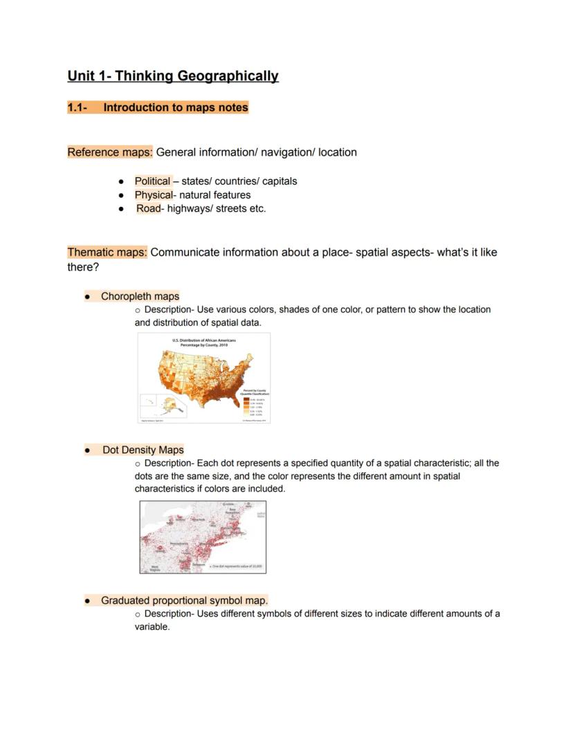
Maps aren't just for finding your way around—they tell stories about our world! There are two main types of maps you'll encounter. Reference maps show general information for navigation and location, including political maps (countries and capitals), physical maps (mountains and rivers), and road maps.
Thematic maps are where geography gets interesting! These show specific information about places. Choropleth maps use different colors or shades to show data distribution (like population density). Dot density maps place dots to represent quantities, where each dot equals a specific value. Graduated symbol maps use differently sized symbols to show varying amounts of something.
Geography Hack: Think of reference maps as "where is it?" maps and thematic maps as "what's it like there?" maps. Knowing which type to use will make your geography projects much easier!
These different map styles help geographers communicate complex information visually. When you see a colorful map showing election results or COVID-19 cases, you're looking at a choropleth map in action!
2
of 10
Understanding Location and Distance
Location can be described in two important ways. Absolute location is the exact, precise position using an address or coordinates (like Rio de Janeiro at 23°S, 43°W). Relative location describes where something is in relation to other places (like "next to the mall" or "between Werk and Lawrence").
Similarly, distance has two perspectives. Absolute distance is the exact measurement in miles or kilometers. Relative distance refers to how connected places feel, regardless of actual miles. Amazon has made distant stores feel close because you can get products delivered in just two days!
Direction also has absolute forms (north, south, east, west) and relative forms ("turn left at Target"). Geographers look for patterns in how things are arranged—whether clustered together densely or dispersed widely across an area.
Map projections always distort something because they try to show our round Earth on flat paper. Cartographers must decide which aspects (shape, area, distance, or direction) they want to preserve most accurately based on the map's purpose.
3
of 10
Map Projections and Spatial Relationships
Have you ever noticed how Greenland looks huge on some maps but much smaller on others? That's because map projections inevitably distort spatial relationships. Remember the acronym S.A.D.D.—all maps distort Shape, Area, Distance, or Direction in some way.
Geographers analyze patterns to understand how things are distributed. Clustering happens when things are close together, creating high density in an area. Dispersal occurs when things are spread far apart. When geographers notice two phenomena appearing in similar patterns, it might indicate a spatial association between them.
Map projections are critical because they show Earth's curved surface on flat paper. Different projections serve different purposes. Some preserve accurate shapes, while others maintain correct area proportions. No single projection can accurately represent everything.
Important Insight: Maps are selective in what they portray! The choice of projection reveals what the mapmaker thinks is most important to represent accurately.
Maps help us understand connections between places, but remember that every map makes compromises in what it shows accurately. A good geographer knows which projection to use for different purposes.
4
of 10
Common Map Projections
The Mercator projection (1569) is probably the map you're most familiar with from classrooms. Its advantages include preserving direction and shape, making it excellent for navigation. The biggest disadvantage? It severely distorts area near the poles, making Greenland look similar in size to Africa (which is actually 14 times larger!).
The Peters Equal Area map takes the opposite approach. Its main advantage is showing accurate land area proportions, giving a better sense of countries' true sizes. However, it stretches shapes dramatically near the equator, making countries look elongated and unfamiliar.
The Robinson projection offers a compromise between the two. It doesn't preserve any single aspect perfectly but avoids major distortions in all categories. This makes it a good choice for general reference maps in textbooks and atlases.
Try This: Next time you look at a world map, check what projection it uses! This will help you understand what's being accurately represented and what's being distorted.
These different projections remind us that there's no perfect way to show our round Earth on flat paper. Each projection makes different trade-offs depending on what the mapmaker considers most important to preserve.
5
of 10
Geographic Data Collection Methods
How do geographers gather all their information? Fieldwork involves physically visiting locations to collect firsthand data through written accounts, interviews, photographs, and direct observations. The US Census is a massive fieldwork operation that collects population data, which impacts everything from voting districts to school funding.
Modern geography relies heavily on geospatial technologies. These include Geographic Information Systems (GIS) for storing and analyzing map data, Global Positioning System (GPS) for precise location tracking, and remote sensing to collect information from aircraft or satellites without actually being there.
These technologies aren't just for professional geographers! Businesses use GIS to decide where to build new stores. City planners analyze traffic patterns to reduce congestion. Environmental scientists track changes in forests and glaciers using satellite imagery.
Real-World Connection: The next time you use navigation on your phone, remember you're using the same GPS technology that geographers use for their research!
Modern geographic data collection combines traditional fieldwork with cutting-edge technology. This powerful combination helps us understand our world in ways that weren't possible just a few decades ago.
6
of 10
Geospatial Technologies in Action
Geographic Information Systems (GIS) are powerful computer systems that store, analyze, and display information from multiple digital maps. Think of GIS like a layer cake of information! One layer might show roads, another layer shows population density, and another shows flood zones. By combining these layers, you can answer complex questions like "What neighborhoods need more evacuation routes during floods?"
GPS uses satellites orbiting Earth to provide precise location information. Beyond helping you navigate to the mall, GPS enables ship captains to navigate safely, farmers to precisely plant crops, and scientists to track animal migrations.
Remote sensing captures images from aircraft or satellites to monitor Earth's surface. Weather forecasts rely on this technology to track storms. Environmental scientists use it to monitor deforestation and pollution. Even your aerial photos on Google Maps come from remote sensing!
Career Connection: Geospatial technology skills are highly valued in many careers—from urban planning and environmental science to business analysis and emergency management.
The spatial perspective in geography asks four key questions: What? Where? Why there? Why care? These technologies help geographers answer all four questions more accurately than ever before.
7
of 10
Understanding Place and Location
What makes New York City different from your hometown? That's what geographers call sense of place—the unique characteristics that make locations special. Think about landmarks, local foods, or distinctive architecture that give places their identity.
A cultural landscape represents all the physical things humans have built in an area—from skyscrapers to highways to farms. These human-created features tell stories about what people value and how they use space. Sometimes places lack distinctive features, becoming what geographers call placeless—like generic strip malls that could be anywhere.
Location can be described in two ways: absolute location (exact coordinates or address) and relative location (in relation to other places). Places also have toponyms (place names) that often reflect local history and culture—like Georgetown named after George Washington.
Climate dramatically shapes places based on latitude and elevation. Areas near the equator receive direct sunlight year-round, creating tropical environments. High-latitude regions get less direct sunlight, resulting in colder climates. Mountains create their own climate patterns—higher elevations are generally cooler than surrounding lowlands.
Geography Challenge: Think about your hometown. What gives it a unique sense of place? What cultural landscape features would a visitor notice first?
8
of 10
Spatial Patterns and Interactions
Geographers love looking for patterns in how things are arranged across space. Sometimes things cluster tightly together (like restaurants in a downtown area). Other times they're dispersed widely (like farms across rural areas). When different phenomena show similar patterns, geographers investigate possible relationships between them.
Regionalization is how geographers divide space into manageable areas for analysis. This helps us understand complex patterns by focusing on smaller, more coherent units rather than trying to analyze the entire world at once.
Spatial interaction describes how places connect through movements of people, goods, and ideas. The strength of these connections typically decreases with distance—a concept called distance decay. You're more likely to shop at nearby stores than travel to distant ones, unless those distant places offer something special.
Time-space compression happens when improved technology makes distant places feel closer and more connected. Your grandparents might have waited weeks for international mail, but you can video chat instantly with people around the world! This compression has accelerated with globalization and advances in transportation and communication technologies.
Diffusion explains how ideas, products, or customs spread from one place to another. Languages, foods, religions, and fashion trends all diffuse across space through human connections and movements.
9
of 10
Human-Environment Interaction
How do humans adapt to their environment, and how do we change it to suit our needs? This relationship is the focus of cultural ecology. Throughout history, people have developed different perspectives on this relationship.
Environmental determinism is the idea that the natural environment directly shapes human behavior and cultural development. This theory claimed that climate determined which societies would advance technologically. Unfortunately, it was historically misused to justify racism, suggesting people in warmer climates were "lazier" than those in temperate regions. While mostly rejected today, environmental factors do influence aspects of human life like clothing styles and farming practices.
Possibilism offers a more balanced view. It acknowledges environmental limitations but emphasizes humans' ability to modify environments to meet our needs. Amazing examples include Dubai's Palm Islands (creating land where there was only ocean), the Hoover Dam (bringing water and power to desert regions), and Incan terraced farming (growing crops on steep mountainsides).
Think Deeper: Next time you see a major construction project, consider it through the lens of possibilism—how are humans overcoming environmental limitations to meet their needs?
Our relationship with the environment continues to evolve as technology advances. Modern societies can overcome more environmental constraints than ever before, but we're also more aware of our impact on natural systems.
10
of 10
Scale of Analysis in Geography
Have you ever zoomed in and out on a digital map? That's changing the scale! Scale is crucial in geography because it determines what patterns become visible. Small-scale maps show large areas with limited detail—perfect for seeing big patterns like climate zones across continents. Large-scale maps show small areas with lots of detail—ideal for navigating city streets.
Remember that small-scale maps have large denominator fractions (like 1:1,000,000), while large-scale maps have small denominators (like 1:10,000). It seems backward until you realize the numbers represent how much the real world has been shrunk to fit on the map!
Geographers analyze patterns at different scales, from global to local:
- Global scale: Worldwide patterns like climate zones or migration flows
- Regional scale: Patterns across multiple countries or states
- National scale: Patterns within a single country
- Local scale: Patterns within cities or neighborhoods
Study Tip: Think about how problems look different at different scales. Traffic congestion might look like a local issue at city scale but becomes part of regional transportation networks at a larger scale.
The scale you choose affects what you can see and understand. Switching between scales often reveals connections between local situations and larger patterns.
We thought you’d never ask...
Our AI companion is specifically built for the needs of students. Based on the millions of content pieces we have on the platform we can provide truly meaningful and relevant answers to students. But its not only about answers, the companion is even more about guiding students through their daily learning challenges, with personalised study plans, quizzes or content pieces in the chat and 100% personalisation based on the students skills and developments.
You can download the app in the Google Play Store and in the Apple App Store.
That's right! Enjoy free access to study content, connect with fellow students, and get instant help – all at your fingertips.
Similar Content
Most popular content in AP Human Geography
9I
Introduction to Geographic Data
Practice identifying types of geographic data, including qualitative and quantitative sources like census data and satellite imagery.
9th5500
I
Introduction to Human-Environmental Interaction
Practice the foundational concepts of environmental determinism and possibilism and their influence on early geographic thought.
9th4520
I
Introduction to Map Properties and Scale
Practice identifying types of map distortion and calculating map scale to understand how physical reality is represented on a flat surface.
9th2860
P
Population: quiz #1!
Master the fundamentals of population with these easy flashcards designed for high school students. Explore key concepts, terms, and examples to ace your exams!
9th1910
U
Unit 2 Measuring Population Density quiz
Measuring Population Density
9th1720
A
AP HUG UNIT 1
This is a little test to help you practice for AP HUG
10th1890
I
Introduction to Geographic Data Scales
Practice identifying and differentiating between local, regional, national, and global scales of analysis using maps and data sets.
9th1810
A
APHUG Unit 1
10 questions just general info you should know if you have listened in your class :D
9th1580
Full Year APHG (Human Geography) Notes
My full Freshman year’s APHG notes compiled on a document.
9th1,920236
Most popular content
9O
Origins and Dynamics of the Columbian Exchange
Analyze the ecological and economic motivations behind the initial transfer of goods, people, and diseases between the Old and New Worlds.
9th3,1280
I
Introduction to Early Cultural Interactions
Analyze the initial social and religious encounters between Europeans, Africans, and Indigenous peoples in the colonial Americas.
9th2,7730
O
Origins of Ancient River Civilizations
Analyze the environmental factors and technological innovations that led to the rise of early states in Mesopotamia, Egypt, and the Indus Valley.
9th3,1870
M
Motivations for European Exploration
Analyze the economic, religious, and political factors that drove European powers to the Americas during the 15th and 16th centuries.
9th1,7780
F
Foundations of Ethical Guidelines in Research
Practice the core principles of the APA ethical code including informed consent, debriefing, and the role of Institutional Review Boards.
9th1,3360
I
Introduction to Native American Societies
Examine the diverse social, political, and economic structures of North American indigenous groups prior to European contact.
9th1,1100
I
Introduction to the Spanish Encomienda System
Explore the fundamental economic and social structures of the Spanish colonial system, focusing on the encomienda and the casta social hierarchy.
9th8890
I
Introduction to Biological Elements of Life
Practice identifying the essential elements including carbon, nitrogen, phosphorus, and sulfur that compose biological macromolecules.
9th1,7410
O
Origins of the Articles of Confederation
Practice identifying the motivations for a weak central government and the specific powers granted to the states under the first U.S. constitution.
9th9370
Students love us — and so will you.
4.6/5App Store
4.7/5Google Play
The app is very easy to use and well designed. I have found everything I was looking for so far and have been able to learn a lot from the presentations! I will definitely use the app for a class assignment! And of course it also helps a lot as an inspiration.
Stefan SiOS user
This app is really great. There are so many study notes and help [...]. My problem subject is French, for example, and the app has so many options for help. Thanks to this app, I have improved my French. I would recommend it to anyone.
Samantha KlichAndroid user
Wow, I am really amazed. I just tried the app because I've seen it advertised many times and was absolutely stunned. This app is THE HELP you want for school and above all, it offers so many things, such as workouts and fact sheets, which have been VERY helpful to me personally.
AnnaiOS user
Comprehensive Notes for AP Human Geography Unit 1 (Topics 1.1-1.7)
Ria@ia_gzyy
Maps and geography help us make sense of our world, from understanding where places are located to how humans interact with their environment. This unit introduces key concepts about maps, geographic data, and spatial relationships that will help you navigate...
1
of 10
Sign up to see the content. It's free!
- Access to all documents
- Improve your grades
- Join milions of students
Types of Maps and Their Uses
Maps aren't just for finding your way around—they tell stories about our world! There are two main types of maps you'll encounter. Reference maps show general information for navigation and location, including political maps (countries and capitals), physical maps (mountains and rivers), and road maps.
Thematic maps are where geography gets interesting! These show specific information about places. Choropleth maps use different colors or shades to show data distribution (like population density). Dot density maps place dots to represent quantities, where each dot equals a specific value. Graduated symbol maps use differently sized symbols to show varying amounts of something.
Geography Hack: Think of reference maps as "where is it?" maps and thematic maps as "what's it like there?" maps. Knowing which type to use will make your geography projects much easier!
These different map styles help geographers communicate complex information visually. When you see a colorful map showing election results or COVID-19 cases, you're looking at a choropleth map in action!
2
of 10Sign up to see the content. It's free!
- Access to all documents
- Improve your grades
- Join milions of students
Understanding Location and Distance
Location can be described in two important ways. Absolute location is the exact, precise position using an address or coordinates (like Rio de Janeiro at 23°S, 43°W). Relative location describes where something is in relation to other places (like "next to the mall" or "between Werk and Lawrence").
Similarly, distance has two perspectives. Absolute distance is the exact measurement in miles or kilometers. Relative distance refers to how connected places feel, regardless of actual miles. Amazon has made distant stores feel close because you can get products delivered in just two days!
Direction also has absolute forms (north, south, east, west) and relative forms ("turn left at Target"). Geographers look for patterns in how things are arranged—whether clustered together densely or dispersed widely across an area.
Map projections always distort something because they try to show our round Earth on flat paper. Cartographers must decide which aspects (shape, area, distance, or direction) they want to preserve most accurately based on the map's purpose.
3
of 10Sign up to see the content. It's free!
- Access to all documents
- Improve your grades
- Join milions of students
Map Projections and Spatial Relationships
Have you ever noticed how Greenland looks huge on some maps but much smaller on others? That's because map projections inevitably distort spatial relationships. Remember the acronym S.A.D.D.—all maps distort Shape, Area, Distance, or Direction in some way.
Geographers analyze patterns to understand how things are distributed. Clustering happens when things are close together, creating high density in an area. Dispersal occurs when things are spread far apart. When geographers notice two phenomena appearing in similar patterns, it might indicate a spatial association between them.
Map projections are critical because they show Earth's curved surface on flat paper. Different projections serve different purposes. Some preserve accurate shapes, while others maintain correct area proportions. No single projection can accurately represent everything.
Important Insight: Maps are selective in what they portray! The choice of projection reveals what the mapmaker thinks is most important to represent accurately.
Maps help us understand connections between places, but remember that every map makes compromises in what it shows accurately. A good geographer knows which projection to use for different purposes.
4
of 10Sign up to see the content. It's free!
- Access to all documents
- Improve your grades
- Join milions of students
Common Map Projections
The Mercator projection (1569) is probably the map you're most familiar with from classrooms. Its advantages include preserving direction and shape, making it excellent for navigation. The biggest disadvantage? It severely distorts area near the poles, making Greenland look similar in size to Africa (which is actually 14 times larger!).
The Peters Equal Area map takes the opposite approach. Its main advantage is showing accurate land area proportions, giving a better sense of countries' true sizes. However, it stretches shapes dramatically near the equator, making countries look elongated and unfamiliar.
The Robinson projection offers a compromise between the two. It doesn't preserve any single aspect perfectly but avoids major distortions in all categories. This makes it a good choice for general reference maps in textbooks and atlases.
Try This: Next time you look at a world map, check what projection it uses! This will help you understand what's being accurately represented and what's being distorted.
These different projections remind us that there's no perfect way to show our round Earth on flat paper. Each projection makes different trade-offs depending on what the mapmaker considers most important to preserve.
5
of 10Sign up to see the content. It's free!
- Access to all documents
- Improve your grades
- Join milions of students
Geographic Data Collection Methods
How do geographers gather all their information? Fieldwork involves physically visiting locations to collect firsthand data through written accounts, interviews, photographs, and direct observations. The US Census is a massive fieldwork operation that collects population data, which impacts everything from voting districts to school funding.
Modern geography relies heavily on geospatial technologies. These include Geographic Information Systems (GIS) for storing and analyzing map data, Global Positioning System (GPS) for precise location tracking, and remote sensing to collect information from aircraft or satellites without actually being there.
These technologies aren't just for professional geographers! Businesses use GIS to decide where to build new stores. City planners analyze traffic patterns to reduce congestion. Environmental scientists track changes in forests and glaciers using satellite imagery.
Real-World Connection: The next time you use navigation on your phone, remember you're using the same GPS technology that geographers use for their research!
Modern geographic data collection combines traditional fieldwork with cutting-edge technology. This powerful combination helps us understand our world in ways that weren't possible just a few decades ago.
6
of 10Sign up to see the content. It's free!
- Access to all documents
- Improve your grades
- Join milions of students
Geospatial Technologies in Action
Geographic Information Systems (GIS) are powerful computer systems that store, analyze, and display information from multiple digital maps. Think of GIS like a layer cake of information! One layer might show roads, another layer shows population density, and another shows flood zones. By combining these layers, you can answer complex questions like "What neighborhoods need more evacuation routes during floods?"
GPS uses satellites orbiting Earth to provide precise location information. Beyond helping you navigate to the mall, GPS enables ship captains to navigate safely, farmers to precisely plant crops, and scientists to track animal migrations.
Remote sensing captures images from aircraft or satellites to monitor Earth's surface. Weather forecasts rely on this technology to track storms. Environmental scientists use it to monitor deforestation and pollution. Even your aerial photos on Google Maps come from remote sensing!
Career Connection: Geospatial technology skills are highly valued in many careers—from urban planning and environmental science to business analysis and emergency management.
The spatial perspective in geography asks four key questions: What? Where? Why there? Why care? These technologies help geographers answer all four questions more accurately than ever before.
7
of 10Sign up to see the content. It's free!
- Access to all documents
- Improve your grades
- Join milions of students
Understanding Place and Location
What makes New York City different from your hometown? That's what geographers call sense of place—the unique characteristics that make locations special. Think about landmarks, local foods, or distinctive architecture that give places their identity.
A cultural landscape represents all the physical things humans have built in an area—from skyscrapers to highways to farms. These human-created features tell stories about what people value and how they use space. Sometimes places lack distinctive features, becoming what geographers call placeless—like generic strip malls that could be anywhere.
Location can be described in two ways: absolute location (exact coordinates or address) and relative location (in relation to other places). Places also have toponyms (place names) that often reflect local history and culture—like Georgetown named after George Washington.
Climate dramatically shapes places based on latitude and elevation. Areas near the equator receive direct sunlight year-round, creating tropical environments. High-latitude regions get less direct sunlight, resulting in colder climates. Mountains create their own climate patterns—higher elevations are generally cooler than surrounding lowlands.
Geography Challenge: Think about your hometown. What gives it a unique sense of place? What cultural landscape features would a visitor notice first?
8
of 10Sign up to see the content. It's free!
- Access to all documents
- Improve your grades
- Join milions of students
Spatial Patterns and Interactions
Geographers love looking for patterns in how things are arranged across space. Sometimes things cluster tightly together (like restaurants in a downtown area). Other times they're dispersed widely (like farms across rural areas). When different phenomena show similar patterns, geographers investigate possible relationships between them.
Regionalization is how geographers divide space into manageable areas for analysis. This helps us understand complex patterns by focusing on smaller, more coherent units rather than trying to analyze the entire world at once.
Spatial interaction describes how places connect through movements of people, goods, and ideas. The strength of these connections typically decreases with distance—a concept called distance decay. You're more likely to shop at nearby stores than travel to distant ones, unless those distant places offer something special.
Time-space compression happens when improved technology makes distant places feel closer and more connected. Your grandparents might have waited weeks for international mail, but you can video chat instantly with people around the world! This compression has accelerated with globalization and advances in transportation and communication technologies.
Diffusion explains how ideas, products, or customs spread from one place to another. Languages, foods, religions, and fashion trends all diffuse across space through human connections and movements.
9
of 10Sign up to see the content. It's free!
- Access to all documents
- Improve your grades
- Join milions of students
Human-Environment Interaction
How do humans adapt to their environment, and how do we change it to suit our needs? This relationship is the focus of cultural ecology. Throughout history, people have developed different perspectives on this relationship.
Environmental determinism is the idea that the natural environment directly shapes human behavior and cultural development. This theory claimed that climate determined which societies would advance technologically. Unfortunately, it was historically misused to justify racism, suggesting people in warmer climates were "lazier" than those in temperate regions. While mostly rejected today, environmental factors do influence aspects of human life like clothing styles and farming practices.
Possibilism offers a more balanced view. It acknowledges environmental limitations but emphasizes humans' ability to modify environments to meet our needs. Amazing examples include Dubai's Palm Islands (creating land where there was only ocean), the Hoover Dam (bringing water and power to desert regions), and Incan terraced farming (growing crops on steep mountainsides).
Think Deeper: Next time you see a major construction project, consider it through the lens of possibilism—how are humans overcoming environmental limitations to meet their needs?
Our relationship with the environment continues to evolve as technology advances. Modern societies can overcome more environmental constraints than ever before, but we're also more aware of our impact on natural systems.
10
of 10Sign up to see the content. It's free!
- Access to all documents
- Improve your grades
- Join milions of students
Scale of Analysis in Geography
Have you ever zoomed in and out on a digital map? That's changing the scale! Scale is crucial in geography because it determines what patterns become visible. Small-scale maps show large areas with limited detail—perfect for seeing big patterns like climate zones across continents. Large-scale maps show small areas with lots of detail—ideal for navigating city streets.
Remember that small-scale maps have large denominator fractions (like 1:1,000,000), while large-scale maps have small denominators (like 1:10,000). It seems backward until you realize the numbers represent how much the real world has been shrunk to fit on the map!
Geographers analyze patterns at different scales, from global to local:
- Global scale: Worldwide patterns like climate zones or migration flows
- Regional scale: Patterns across multiple countries or states
- National scale: Patterns within a single country
- Local scale: Patterns within cities or neighborhoods
Study Tip: Think about how problems look different at different scales. Traffic congestion might look like a local issue at city scale but becomes part of regional transportation networks at a larger scale.
The scale you choose affects what you can see and understand. Switching between scales often reveals connections between local situations and larger patterns.
We thought you’d never ask...
Our AI companion is specifically built for the needs of students. Based on the millions of content pieces we have on the platform we can provide truly meaningful and relevant answers to students. But its not only about answers, the companion is even more about guiding students through their daily learning challenges, with personalised study plans, quizzes or content pieces in the chat and 100% personalisation based on the students skills and developments.
You can download the app in the Google Play Store and in the Apple App Store.
That's right! Enjoy free access to study content, connect with fellow students, and get instant help – all at your fingertips.
Similar Content
Most popular content in AP Human Geography
9I
Introduction to Geographic Data
Practice identifying types of geographic data, including qualitative and quantitative sources like census data and satellite imagery.
9th5500
I
Introduction to Human-Environmental Interaction
Practice the foundational concepts of environmental determinism and possibilism and their influence on early geographic thought.
9th4520
I
Introduction to Map Properties and Scale
Practice identifying types of map distortion and calculating map scale to understand how physical reality is represented on a flat surface.
9th2860
P
Population: quiz #1!
Master the fundamentals of population with these easy flashcards designed for high school students. Explore key concepts, terms, and examples to ace your exams!
9th1910
U
Unit 2 Measuring Population Density quiz
Measuring Population Density
9th1720
A
AP HUG UNIT 1
This is a little test to help you practice for AP HUG
10th1890
I
Introduction to Geographic Data Scales
Practice identifying and differentiating between local, regional, national, and global scales of analysis using maps and data sets.
9th1810
A
APHUG Unit 1
10 questions just general info you should know if you have listened in your class :D
9th1580
Full Year APHG (Human Geography) Notes
My full Freshman year’s APHG notes compiled on a document.
9th1,920236
Most popular content
9O
Origins and Dynamics of the Columbian Exchange
Analyze the ecological and economic motivations behind the initial transfer of goods, people, and diseases between the Old and New Worlds.
9th3,1280
I
Introduction to Early Cultural Interactions
Analyze the initial social and religious encounters between Europeans, Africans, and Indigenous peoples in the colonial Americas.
9th2,7730
O
Origins of Ancient River Civilizations
Analyze the environmental factors and technological innovations that led to the rise of early states in Mesopotamia, Egypt, and the Indus Valley.
9th3,1870
M
Motivations for European Exploration
Analyze the economic, religious, and political factors that drove European powers to the Americas during the 15th and 16th centuries.
9th1,7780
F
Foundations of Ethical Guidelines in Research
Practice the core principles of the APA ethical code including informed consent, debriefing, and the role of Institutional Review Boards.
9th1,3360
I
Introduction to Native American Societies
Examine the diverse social, political, and economic structures of North American indigenous groups prior to European contact.
9th1,1100
I
Introduction to the Spanish Encomienda System
Explore the fundamental economic and social structures of the Spanish colonial system, focusing on the encomienda and the casta social hierarchy.
9th8890
I
Introduction to Biological Elements of Life
Practice identifying the essential elements including carbon, nitrogen, phosphorus, and sulfur that compose biological macromolecules.
9th1,7410
O
Origins of the Articles of Confederation
Practice identifying the motivations for a weak central government and the specific powers granted to the states under the first U.S. constitution.
9th9370
Students love us — and so will you.
4.6/5App Store
4.7/5Google Play
The app is very easy to use and well designed. I have found everything I was looking for so far and have been able to learn a lot from the presentations! I will definitely use the app for a class assignment! And of course it also helps a lot as an inspiration.
Stefan SiOS user
This app is really great. There are so many study notes and help [...]. My problem subject is French, for example, and the app has so many options for help. Thanks to this app, I have improved my French. I would recommend it to anyone.
Samantha KlichAndroid user
Wow, I am really amazed. I just tried the app because I've seen it advertised many times and was absolutely stunned. This app is THE HELP you want for school and above all, it offers so many things, such as workouts and fact sheets, which have been VERY helpful to me personally.
AnnaiOS user